


















By Kevin P. Corbley
 Researchers at Shandong University of Science and Technology in China have developed a technique using AI-guided Unmanned Aerial Vehicles (UAVs) to more accurately and efficiently monitor an endangered seal species in Chinese waters. This technique has the potential for deployment in tracking and inventorying a wide variety of dynamic wildlife populations.
“The spotted seal is the only pinniped [fin-footed] marine mammal capable of natural reproduction in Chinese waters,” wrote the researchers in a 2026 IEEE J-STARS paper. “It has experienced a significant population decline over the past century, primarily due to habitat destruction and marine environmental degradation.”
The favored habitat of the spotted seal in China is Liaodong Bay within the Bohai Sea in the northeastern part of the country. National ecological protection efforts have focused on dynamic monitoring and conservation of the seals in this area. However, tracking the animals has proved challenging – as is the case with nearly any wildlife constantly on the move. Manually observing and counting the seals has been insufficient to meet the objectives of the conservation program.
A solution was proposed to use UAVs flying above Liaodong Bay to capture video of the seals as a more efficient inventory method. It should be noted that UAV use in wildlife monitoring is a relatively common technique in conservation projects elsewhere in the world. The Shandong researchers, however, saw problems with the implementation of this remote sensing technology and set about to find a better way to utilize the UAVs for seal counting.
The researchers observed the primary drawback in UAV use is that simple static preplanned flight routes are employed to cover the area of interest in patterns designed to ensure sufficient overlap. But while this method efficiently maps the overall habitat without gaps in the video, evaluation revealed the animal counts taken from the data are inaccurate.
The main reason is that static flightlines are inadequate to monitor a population constantly shifting with tides, weather changes, and human disturbances. The moving seals are either missed entirely by the video, or the video itself contains huge swaths of empty habitat, a costly inefficient use of flight time and analysis.
Putting AI Onboard the UAV
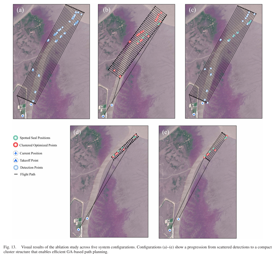
The Shandong researchers proposed replacing the traditional static flight plans with adaptive AI-based real-time UAV navigation using onboard edge intelligence. In other words, the UAV would optimize its flight path during flight in response to movement by the seals. The researchers called this a perception-drive approach that adapts to the uncertain movement of the seals.
The technique combines onboard YOLOv11-based target detection, multi-object tracking, visual positioning, and spatial noise filtering. These elements find clusters of seals and ensure they are captured on video while also making sure they are not included multiple times in the video. Objects that might be mis-interpreted as seals are filtered out quite accurately. Areas with no seals are deleted from the flight path.
A genetic algorithm developed by the Shandong research team integrates this information in real time aboard the drone to generate the most efficient zigzag coverage pattern through the area of interest. Not only is the path optimized to capture video of all the seals in the area, it calculates a time- and fuel-efficient route with minimal turns, shortest overall flight distance, and sufficient image overlap for photogrammetric processing.
The edge-computing technique continually recalculates the UAV route in response to movement of the seals to make sure they are all included in the video inventory.
Implementation of the path-optimization technique in Liaodong Bay significantly improved the spatial reliability of seal monitoring with a UAV during tests conducted by the University of Shandong research team in coordination with colleagues at the North China Sea Ecological Center. The next phase of research will seek to apply the methodology to monitoring other dynamically distributed wildlife populations.
Please read the full J-STARS paper here: ieeexplore.ieee.org/stamp/stamp.jsp?tp=&arnumber=11363417