Organization
The ESI Technical Committee encourages participation from all its members. The committee organization includes the Chair, two Co-Chairs, and 2 working groups.
ESI Technical Committee Chair
 | Dr. Manil Maskey NASA manil.maskey@nasa.gov |
ESI Technical Committee Co-Chair
 | Prof. Dr. Peter Baumann Constructor University, Germany p.baumann@jacobs-university.de |
 | Prof. Dr. Gabriele Cavallaro Forschungszentrum Jülich and University of Iceland g.cavallaro@fz-juelich.de |
WG-HDCRS Lead
 | Prof. Dr. Dora Blanco Heras CiTIUS – University of Santiago de Compostela dora.blanco@usc.es |
WG-HDCRS Co-Lead
 | Dr. Rocco Sedona Forschungszentrum Jülich r.sedona@fz-juelich.de |
 | Iksha Gurung University of Alabama in Huntsville ig0004@uah.edu |
 | Prof. Dr. Sudan Jha Kathmandu University sudan.jha@ku.edu.np |
WG-DBRS Lead
 | Muthukumaran Ramasubramanian University of Alabama in Huntsville mr0051@uah.edu |
WG-DBRS Co-Lead
 | Dr. Kesheng (John) Wu Lawrence Berkeley National Laboratory, USA kwu@lbl.gov |
 | Prof. Khalid Belhajjame Paris-Dauphine University, France kbelhajj@googlemail.com |
AIFMDTG Lead
 | Dr Sujit Roy NASA IMPACT sujit.roy@uah.edu |
AIFMDTG Co-Lead
 | Dr. Rajat Shinde NASA IMPACT rajatshinde@iitb.ac.in |
 | Dr. Johannes Schmude IBM Research johannes.schmude@ibm.com |
ESI Technical Committee Secretary
 | Jerika Christman NASA/Marshall Space Flight Center jerika.h.christman@nasa.gov |
News
July 2023: new Strategic Initiative unveiled: IEEE GRSS EO datacube infrastructure, EO-Cube.
GRSS co-sponsored workshop highlighted in AGU Eos article on “Advancing AI for Earth Science: A Data Systems Perspective”
International expert workshop to discuss how best to use machine learning (ML) techniques on NASA’s Earth Observation (EO) data and address environmental challenges (pdf)
SAR experts collaborate with data labelers to generate Machine Learning Training dataset for flood detection
GRSS ESI co-organized events and conference contributions
- July 2023: At IGARSS 2023, the new Strategic Initiative project “EO-Cube” will be presented to the audience first time.
- IGARSS 2023 invited sessions:
- CCS.30: Advances in Spatio-Temporal Datacube Management, Visualization, Analytics and AI (IEEE ESI Committee session)
- CCS.136: Standards Evolution II: Data Management, Services, and Federation (joint session by IEEE GRSS ESI and Standards Committees)
- IGARSS 2021 invited sessions:
- Artificial Intelligence and Machine Learning Methods for Big Earth Data
- OGC/ISO Coverages: Concepts, Tools, Experiences
- January 2020: Organized an international expert workshop to discuss how best to use machine learning (ML) techniques on NASA’s Earth Observation (EO) data and address environmental challenges. (Supported by NASA Earth Science Data Systems program and GRSS ESI) conference report pdf
- IGARSS 2019 Conference:
- TU3.R7: Analytics on Datacubes & Analysis Ready Earth Data (session supported by GRSS ESI, OGC, ISO, and INSPIRE)
- FR2.R4: Earth Observation Science and Exploitation using Common Standards and Platforms Session I and Session II (invited sessions, supported by OGC and GRSS ESI)
- FR3.R7: Advances on Analysis of Big Data in Remote Sensing Session I and Session II (sessions supported by GRSS ESI)
- MO4.R3.2: Remote Sensing Analytics in Databases with ISO SQL/MDA (ESI contribution to MO4.R3: Advancing Remote Sensing in the Geosciences through Standardization II)
- 2018 International Workshop on Big Geospatial Data and Data Science (BGDDS 2018): ESI TC has co-organized the 2018 International Workshop on Big Geospatial Data and Data Science (BGDDS 2018), held at Wuhan University on 22-23 September 2018.
- IGARSS 2017 Conference Technical Program
- IGARSS Special Sessions 2002 – 2011
Standardization: ESI contributions
ESI members are continuously contributing to standardization, in particular of Big Datacubes. They also contribute actively, in design and implementation, to advances in standardization, such as in the OGC OpenAPI Hackathon in London (June 2019). A liaison agreement with OGC is in place. Below is a list of standards, most of them led by ESI members, others with significant contributions:
- ISO SC32 Data Management and Interchange:
- ISO TC211 Geographic Information / Geomatics:
- ISO 19123-1: Geographic information – Schema for coverage geometry and functions – Part 1: Fundamentals (adopted standard)
- ISO 19123-2: Geographic information – Schema for coverage geometry and functions – Part 2: Coverage Implementation Schema (adopted standard)
- ISO 19123-3: Geographic information – Schema for coverage geometry and functions – Part 3: Processing Fundamentals (adopted standard)
- Open Geospatial Consortium:
- OGC 09-146: Coverage Implementation Schema (adopted standard)
- OGC 09-110: WCS Interface Standard – Core (adopted standard)
- OGC 13-057: WCS Interface Standard – Transaction Extension (adopted standard)
- OGC 12-040: WCS Interface Standard – Range Subsetting Extension (adopted standard)
- OGC 08-059: WCS Interface Standard – Processing Extension (adopted standard)
- OGC 12-039: WCS Interface Standard – Scaling Extension (adopted standard)
- OGC 11-053: WCS Interface Standard – CRS Extension (adopted standard)
- OGC 12-049: WCS Interface Standard – Interpolation Extension (adopted standard)
- OGC 09-149: WCS Interface Standard – XML/SOAP protocol extension (adopted standard)
- OGC 09-148: WCS Interface Standard – XML/POST protocol extension (adopted standard)
- OGC 09-147: WCS Interface Standard – KVP protocol extension (adopted standard)
- OGC 10-140: WCS Application Profile – Earth Observation (adopted standard)
- OGC 14-052: WCS Application Profile – MetOcean (candidate standard)
- OGC 12-174: WCS Interface Standard – REST protocol extension (candidate standard)
- OGC 08-068: Web Coverage Processing Service (WCPS) Language (adopted standard)
Society Outreach
The 1 hour TV documentary Big Earth Data: the Digitized Planet has been created by Peter Baumann and Heike Hoenig, produced by German TV stations ZDF and ARTE, winning an award at the 2015 International Science Film Festival in Hungary. See more background.
ESI Committee Meeting Presentations
Focus Areas
Focus areas investigated by the ESI membership include, but are not limited to:
- Data stewardship
- Data and metadata standards
- Data search and discovery
- Data cubes
- Machine/Deep learning
- Knowledge representation
- Big data
- Visualization
- Web services/APIs
- Geographic information systems
- Information modeling
- Data storage
- Open science
- Science analytics platform
- Semantic web
The mission of HDCRS
The HDCRS working group is part of the IEEE GRSS Earth Science Informatics (ESI) Technical Committee. The main objective of HDCRS is to connect a community of interdisciplinary researchers in remote sensing who are specialized on high-performance and distributed computing, quantum computing and parallel programming models with specialized hardware accelerators.
HDCRS disseminates information and knowledge through educational events, special sessions and tutorials at conferences and publication activities. The group welcomes anyone interested from academia and industry to contribute to our mission.
Graph databases, knowledge graph, graph visualization tools/application for managing data and metadata in remote sensing
Native graph databases (GDBs) store and manage data as triples of graph components (i.e., nodes and relationships). GDBs treat the relationships as equal as nodes, advancing the capability of discovery and analysis on the connectivity of data. In this topic, we seek and encourage theoretical and practical advancements in Graph database (GDB) and knowledge graph (KG) for management, discovery and analysis of remotely sensed images and metadata.
Novel solutions for harmonizing remote sensing observations in their native geometries and layouts
Remote sensing observation data are often pre-processed, transformed (usually through interpolation), and composited into a different format or layout to smooth the analysis process. However, scientific investigations usually require remote sensing data in their native forms, or as close as possible. We will thus cultivate and promote database advances that facilitate fusional analysis of diverse remote sensing data at their native observation geometries and layouts.
Datacubes, array databases for Remote Sensing data
Remote sensing data is immigrating to the cloud, paving the new ways of managing and processing remote sensing data. Datacube has emerged as a novel paradigm for massive remote sensing data analysis as its data-representation characteristics allow:
- Taking full advantages of distributed, concurrent and parallel processing and storage of cloud platforms.
- Efficiently supporting smart data access that significantly reduces the amount of data access.
This research topic focuses on the innovation technologies and methods that effectively transfer remote sensing data into Datacubes as well as novel array databases that offer Datacubes analysis-ready for any massive remote sensing needs.
Resources
Relevant Standards Bodies
- INSPIRE: Infrastructure for spatial information in Europe
- ISO TC211: Task Committee on Geographic Information
- Open Geospatial Consortium
- US Federal Geographic Data Committee
Projects, Tools, and Initiatives (alphabetically)
- EarthServer Initiative: Big Earth Datacubes at your fingertips
- NASA Earth Science Data and Information System project
- OPeNDAP/DODS project
- rasdaman: Scalable datacube analytics
Webinars
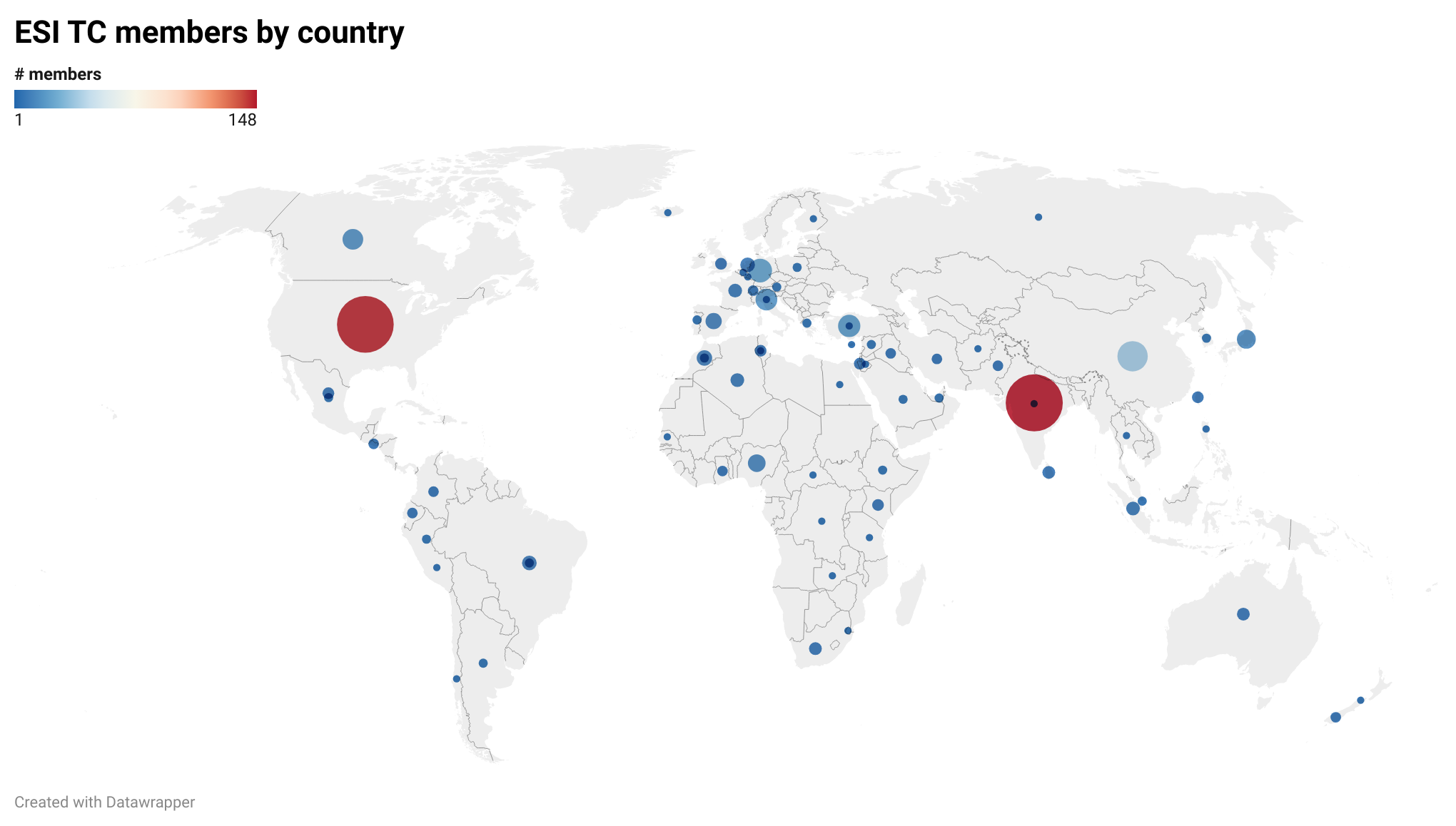
Current membership (as of December 2023)
You can contact the Committee Chairs by email at esi_chairs@grss-ieee.org.
Membership in the ESI Technical Committee is open to anyone interested in issues related to earth science informatics. IEEE Geoscience and Remote Society membership is encouraged, but not required to join the ESI Technical Committee. Join the ESI Technical Committee!