


Written by: Madeleine Dawson, Content and Design Staff for IEEE GRSS
Background
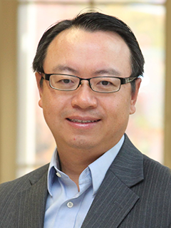
Satellite remote sensing has transformed how scientists observe the Earth system, from monitoring precipitation to tracking environmental change across the planet, but its greatest impact emerges when innovation intersects with real-world societal challenges. For Dr. Yang Hong, Gallogly Chair Professor of hydrology and remote sensing at the University of Oklahoma, director of the HyDROS Laboratory at the National Weather Center, and affiliated faculty at the Advanced Radar Research Center, this intersection defines his career. An IEEE Senior Member with a foundation in hydrology, he focuses on transforming satellite-derived precipitation data into operational systems for predicting water-related hazards such as floods, landslides, and droughts. His academic path began with a bachelor’s degree in geoscience and a master’s degree in environmental science. During his PhD in hydrology and water resources at the University of Arizona, Tucson, he was introduced to remote sensing, a turning point that reshaped his research trajectory. His work centers on integrating remote sensing with hydrologic modeling to address global water challenges, guided by a “sensor-to-society” framework that emphasizes transforming advanced sensing technologies into actionable tools for disaster preparedness, water resource management, and climate resilience. Through this interdisciplinary approach, Dr. Hong demonstrates how innovations developed within the IEEE Geoscience and Remote Sensing Society can be translated into real-world solutions that strengthen global water security.
Can you introduce yourself and share a brief background about who you are and what you do?
I am a professor of hydrology and remote sensing at the University of Oklahoma. My research focuses on remote sensing precipitation retrieval and its integration with hydrologic modeling to better understand and predict water-related hazards. Over the past two decades, my work has centered on transforming Earth observations—particularly satellite precipitation—into operational prediction systems that help communities manage water-related disasters.
My career path is somewhat atypical within IEEE because my academic training is rooted in Earth and environmental science rather than electrical engineering. During my doctoral studies, however, my dissertation focused on retrieving global precipitation from NASA satellite missions, which required me to pursue a Ph.D. minor in remote sensing. That accidental experience fundamentally changed my research direction. Since then, nearly everything I do depends on technologies developed by the IEEE community—sensors, retrieval algorithms, and large-scale remote sensing data systems. My goal has been to build end-to-end systems that connect remote sensing, environmental modeling, and societal decision-making to better manage water, weather, and climate risks.
How long have you been a member? Tell us about your GRSS journey.
I became a student member in 2003 while attending my first IGARSS conference in Honolulu, Hawaii. Following this, I worked at NASA Goddard on satellite missions such as the Tropical Rainfall Measuring Mission and later the Global Precipitation Measurement (GPM) mission. These missions demonstrated how advances in remote sensing technology could fundamentally change how we observe precipitation and hydrologic processes on a global scale. I later joined the University of Oklahoma in a radar hydrology faculty position and became affiliated faculty with the Advanced Radar Research Center (arrc.ou.edu) at the National Weather Center (nwc.ou.edu), a unique environment where sensor engineers, Earth scientists and operational forecasting agencies work side by side.
Through those collaborations, I became increasingly engaged with the GRSS community by attending conferences and publishing on IEEE journals. GRSS provides an intellectual home where technological innovation meets real-world environmental applications.
“GRSS is where the engineers who build the sensors and the scientists who use the data come together to understand our planet.”
What inspired you to join GRSS?
I was most inspired by seeing how rapidly sensor technology was transforming our ability to observe the Earth system. Hydrology traditionally relied heavily on in-situ measurements such as rain gauges and stream stations. While these measurements remain essential, they are sparse in many parts of the world. Remote sensing changed that paradigm by allowing us to observe precipitation and other hydrologic variables continuously across the globe. GRSS represents the community that designs these sensors, develops the algorithms, and advances the technologies that make these observations possible. For someone working on hydrology and natural hazards, being connected to that technological frontier is both exciting and essential.
“Satellite remote sensing provides the only practical way to observe the global water cycle and environmental changes continuously.”
How has GRSS contributed to your professional growth?
GRSS has played an important role in shaping my interdisciplinary perspective by bringing together communities that often work separately—engineers designing sensors, scientists developing retrieval algorithms, and practitioners applying those observations to Earth system problems. Through GRSS journal publications, conferences, and collaborations, I have had the opportunity to interact with experts working on everything from instrument calibration to image analysis and artificial intelligence. These exchanges have helped me better understand how technological advances in remote sensing can translate into new capabilities for hydrologic prediction and environmental monitoring.
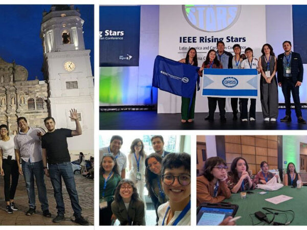
Particularly in reference to the IGARSS conference, I have been able to attend a few over the years in Japan, Beijing, and Hawaii. During these conferences, I established connections and had discussions with many other researchers and scientists. IGARSS is more than just a meeting, it is an excellent platform for collaboration.
“GRSS provides a rare platform where technology development and Earth system applications meet in the same conference.”
What advice would you give to individuals considering joining the GRSS community?
For senior researchers, think beyond disciplinary boundaries. In my domain, we get so comfortable as we grow in our careers. You become more reserved to step outside of your comfort zone. Lately, I have began to work on AI. I used to be reserved about its use case, but now I actively integrate it into my work. Stay open minded on all fronts.
The technologies developed within GRSS—sensors, algorithms, and data—are increasingly shaping many fields beyond remote sensing, including weather, water, climate, environment, agriculture, and disaster management.
For young researchers in particular, GRSS offers an opportunity to work at the intersection of engineering innovation and real-world challenges. Some of the most exciting scientific advances occur when remote sensing technology is integrated with other disciplines to address global problems such as climate change, water security, and hydrologic extremes.
“The greatest impact of remote sensing often happens when technology meets real-world problems.”
Research Profile
What sector/theme/topics does your research focus on?
My research focuses on the intersection of satellite precipitation measurement, hydrologic modeling, and water hazard prediction. A major component of my work involves using Earth observations to drive distributed hydrologic models that predict water availability and extremes-triggered hazards such as floods, droughts and landslides across large regions.
More broadly, my research is anchored in what I describe as a “sensor-to-society” framework—transforming Earth observations into actionable information for societal benefits, combining sensor technology, numerical modeling, and data assimilation techniques to create prediction systems that support disaster preparedness and water resource management.
“Satellite observations give us the eyes to see the global water cycle; hydrologic models translate those observations into predictions that matter for society.”
What key advancement(s) are you proud of in your work?
One advancement I am particularly proud of is the development of the global precipitation system PERSIANN-CCS at hydrologically relevant scales, as well as development of the remote sensing-native CREST hydrologic model family for predicting water storage, movements, and variability across scales. This work demonstrated that satellite precipitation data can be effectively integrated with hydrologic models to simulate water dynamics even in regions where traditional ground observations are limited in the Global South. Another important part of my work has been translating ground weather radar rainfall into National operational flash flood monitoring and early warning systems at very high resolution (500 meter and 5-minute). Through collaborations with agencies such as NASA/USAID and NOAA, these technologies have been incorporated into hazard monitoring systems that help communities better prepare for high-impact hydrologic events.
Another advancement I am proud of is the educational innovation aimed at bridging remote sensing technology with traditional civil and environmental engineering training. Historically, many hydrologists and water engineers were trained primarily using ground-based observations and classical hydrologic methods, with limited exposure to satellite Earth observations. To address this gap, I have worked to integrate remote sensing and Earth observation knowledge into civil engineering and hydrology curricula so that the next generation of engineers can fully utilize remote sensing data in water science and hazard prediction.
I led the establishment of the Hydrology and Water Security (HWS) online master’s program, which trains working professionals from government agencies, industry, and international organizations. The program emphasizes the practical use of satellite observations, radar data, and environmental modeling for water management, hazard monitoring, and climate resilience. Through this effort, hundreds of professionals—from weather services to water agencies—have gained the skills needed to integrate remote sensing technology into operational decision-making.
“Advancing remote sensing technology is important, but equally important is training practitioners and decision-makers who know how to use these technologies to solve real-world water challenges.”
How does your work fit into IEEE GRSS society?
The first two pillars of my work–satellite precipitation retrieval and remote sensing-native hydrology modeling–are closely aligned with the core technical interests of the GRSS society. The third pillar focuses on translating this into hydrologic hazard prediction systems that address real societal challenges. In that sense, my research extends the impact of GRSS innovations into areas such as water resource management, disaster risk reduction, and climate resilience.
“GRSS technologies are the foundation of my work that translates those innovations into societal impact.”
Anything else to share? Conferences or events you are looking to attend?
I always enjoy participating in conferences where engineers, Earth scientists, and application communities come together. These interdisciplinary environments often spark new ideas and collaborations. The rapid evolution of satellite missions, along with advances in AI-driven earth system modeling, is creating exciting opportunities for remote sensing to further transform environmental prediction. Looking ahead, I am particularly excited about how next-generation Earth observation systems and AI-driven modeling approaches can strengthen the connection between satellite sensing and societal decision-making.
“The future of remote sensing lies not only in observing the Earth, but in helping societies make better decisions in a changing world.”
Closing Perspective
Hong’s career highlights the expanding role of remote sensing technologies in addressing global environmental challenges. By integrating satellite observations with hydrologic modeling and hazard prediction systems, his work demonstrates how engineering innovation can directly contribute to disaster resilience and water security. As satellite missions and artificial intelligence continue to evolve, the connection between Earth observation technology and societal applications will only become stronger. For researchers working at this intersection, the GRSS community provides a unique platform where engineering advances can translate into solutions that benefit communities around the world.
“Remote sensing technology becomes truly powerful when it moves from measuring the Earth to protecting people and strengthening societal resilience. My career has been shaped by connecting sensing technologies with hydrologic systems that help communities better manage water resources and hydrologic disasters.”
Do you know an IEEE GRSS professional member who deserves to be recognized? We invite you to submit a nomination by sending a brief message to ir_pub@grss-ieee.org with the subject: “Professional Member Spotlight.”
Not yet a member? Learn more about IEEE GRSS membership and join us today: GRSS Membership.