The IEEE Geoscience and Remote Sensing Society Young Professionals are proud to announce the winners of our 2023 Earth at Risk Image contest.
Our contest had over 35 amazing entries spanning over 15 countries. We were delighted to see the efforts and thoughts behind these submissions for the second edition of this contest. The motivation of highlighting environmental issues through remote sensing and geospatial technologies was reflected in the quality of images we received.
As before, this year’s contest was judged by the REACT Technical Committee team:
Prof. Irena Hanjsek from ETH Zürich and German Aerospace Center, Dr. Carlos Lopez Martinez from Universitat Politècnica de Catalunya, and Prof. Avik Bhattacharya for the Indian Institute of Technology Bombay.
We want to thank all of the entrants to this year’s contest! It has been an honor to witness each of your work.
We are pleased to share the top three images selected by our judges and the people’s choice from the public vote.
Check below to see the images that amazed everyone the most.
FIRST PLACE:
Sandeep Kumar, Indian Institute of Technology, Bombay, India
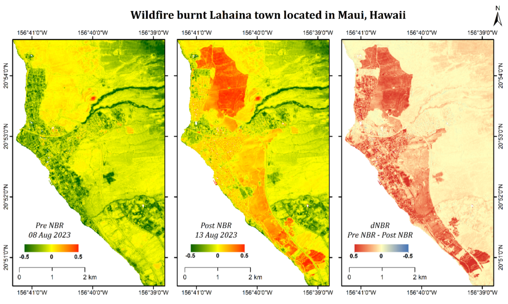
“In recent years, the frequency of wildfires has increased drastically due to global warming and climate change. There are three major elements required for forest fire: oxygen, fuel, and heat. Oxygen helps fuel to burn and is present everywhere in the air. The carbon stored in the forest acts as fuel. The increase in global temperature decreases the fuel moisture content and hence reduces the ignition temperature of the fuel. Thus, it helps to catch fire easily. Recent Wildfires on Maui island of Hawaii damaged not only the forest resources but also people’s homes, which led to the loss of life for several people. The image shows pre-fire NBR (Normalized Burn Ratio), post-fire NBR, and dNBR (Differenced NBR) for the fire-affected region of Lahaiana, located in Maui island of Hawaii. The images used were acquired from the Sentinel-2 satellite on the 08th of August and the 13th of August. According to the official report, 115 people have lost their lives in this fire, and around 382 people were still missing till the 24th of August.” Sandeep Kumar
SECOND PLACE:
Fatma Elik, Istanbul Technical University, Istanbul, Turkey
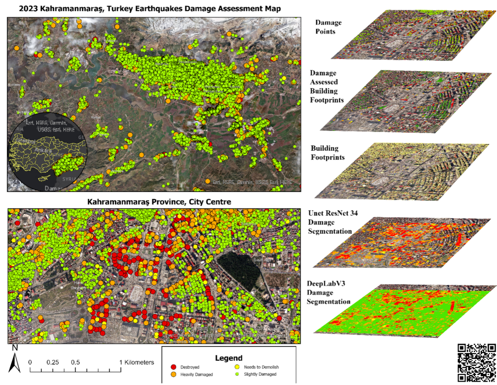
“The map presented provides a holistic overview of earthquake activity and its aftermath in Kahramanmaraş, Turkey, presenting a vital tool for research, urban planning, and disaster management. Showcasing earthquake-prone zones, damage assessment points, building footprints, and the extent of assessed damage, it offers a multi-faceted perspective. Moreover, the integration of high-resolution Maxar satellite images enhances its comprehensiveness. These images vividly portray Turkey’s landscape and the Kahramanmaraş province, providing a detailed depiction of terrain, urban centers, and the impact of the earthquake on the environment. The map amalgamates earthquake data, building footprints, damage evaluations, labels, and satellite imagery, providing a comprehensive grasp of the earthquake’s implications for Kahramanmaraş and the broader Turkish context. It facilitates analyses by researchers, urban planners, and disaster management authorities, enabling them to discern seismic event effects and strategize recovery efforts effectively. Notably, the map boasts a QR code that directly links to your master’s thesis-derived dashboard website. This interactive platform enables users to explore in-depth visualizations, analytical tools, and findings, fostering engagement with your research outcomes. This innovation seamlessly integrates your academic work with practical applications, rendering the map an invaluable resource for comprehending seismic events, devising recovery strategies, and advancing earthquake resilience discussions.” Fatima Elik
THIRD PLACE
Adedewe Abiodun Faith, Federal University of Technology, Akure, Nigeria
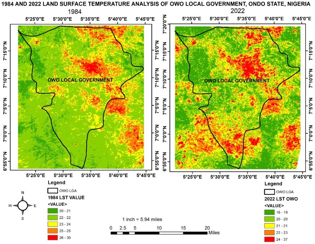
“Owo is a local government area in Ondo state, Nigeria. Between 1400 and 1600 CE, it was the capital of a Yoruba city-state. The local government area has a population of 222,262 based on 2006 population census. The analysis of land surface temperature is a critical component of climate change monitoring. This worldwide crisis necessitates immediate, coordinated response at all levels of human society. The imagery depicts Land Surface Temperature Analysis maps for Owo Local Government for 1984 and 2022. The reported lowest and hottest temperatures show a significant difference. The maximum temperature in 1984 was 30 degrees Celsius, but by 2022, it had risen to 37 degrees Celsius. This difference highlights a substantial temperature shift between the two years, requiring our attention. The imagery is based on Earth Observation data from the Landsat 5 (1984) and Landsat 8 (2022) satellites, both of which are classified as type 1. Cloud cover is less than 1% for these multispectral satellites. This method can also be used to assess the level of action in our efforts to reduce the impact of climate.” Adedewe Abiodun Faith
PEOPLE’S CHOICE:
Adewale Olayemi, University of Lagos, Nigeria
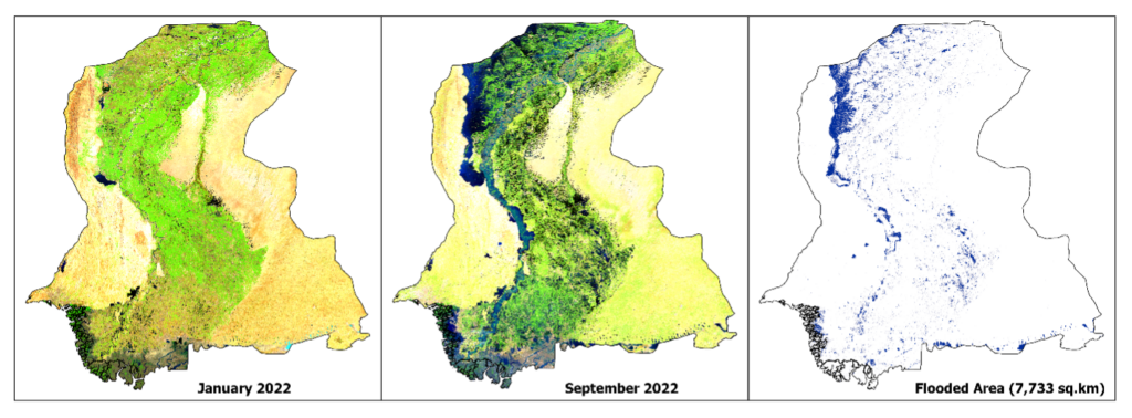
“In mid-2022, a devastating flood impacted a large part of the Sindh province in Pakistan following heavy monsoon rains. This event led to the deaths of over 1,000 people, with more than 10 million individuals being displaced. Sentinel-2, a satellite developed by the European Space Agency (ESA), captured images in January and September 2022 that clearly illustrate the before and after effects of the flooding in Sindh. The attached false-color composite images, using shortwave infrared, near infrared, and green bands, highlight the dramatic changes. They show a substantial expanse of once green land transformed into blue-flooded regions. Detection of the flooded areas was achieved using the Normalized Difference Water Index (NDWI) and the Modified NDWI (MNDWI), which classified water and non-water pixels in both images before and after the flood. The images reveal that the flood impacted an area of over 7,733 sq. km of land. The flood detection image demonstrates the power of remote sensing in understanding environmental threats and mitigating damage. Through sophisticated processing, raw earth observation data becomes actionable intelligence. Whether dealing with flooding, fires, or deforestation, these “eyes in the sky” contribute to safeguarding our planet.” Adewale Olayemi
The complete gallery for the images submitted can be visited here.
Congratulations to the Earth at Risk Image Contest Winners for 2023 and we look forward to your participation in 2024!!!