


By Joanne Van Voorhis
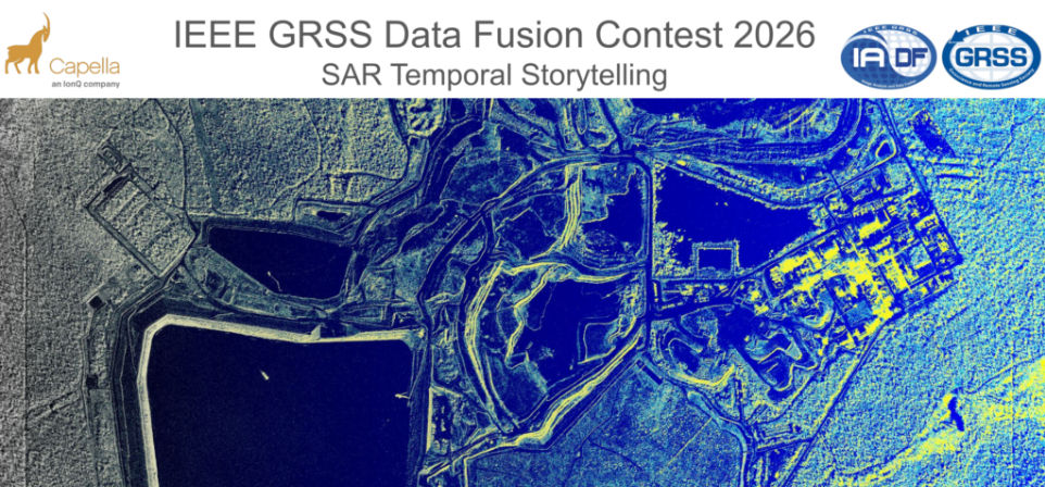
For the past two decades, the IEEE Geoscience and Remote Sensing Society (GRSS) has hosted an annual Data Fusion Contest that challenges participants to tackle issues in processing large-scale, multisensor, multimodal, and multi-temporal Earth Observation data. By presenting complex problem scenarios and providing high-quality benchmark datasets, the contest consistently pushes the boundaries of remote sensing image analysis. This year’s 2026 IEEE GRSS Data Fusion Contest, organized by the GRSS Image Analysis and Data Fusion (IADF) Technical Committee of GRSS and Capella Space, focused on a problem at the forefront of modern radar remote sensing: how to extract consistent temporal insight from Synthetic Aperture Radar (SAR) data acquired across a wide range of imaging modes and viewing geometries.
“For 2026, we wanted to move beyond just ‘taking a picture’ from space. We focused on temporal storytelling, which is the ability to look at a sequence of SAR images over time to understand how a landscape is moving or changing. By releasing the first-ever large-scale commercial radar dataset of its kind, we hoped to see researchers develop tools that don’t just identify what is on the ground, but how it is evolving, regardless of weather or light,” explains IADF Technical Committee Co-Chair, Ujjwal Verma. “Unlike past contests where the contest objective was pre-defined, the 2026 DFC was an open laboratory for innovation. By releasing a massive, commercially sourced dataset, we encouraged researchers to move beyond chasing metrics and instead focus on creative exploration. Our goal was to encourage techniques that truly push the boundaries of how we interpret long-term SAR observations.”
The 2026 Challenge: SAR Temporal Storytelling at Scale
The 2026 contest dataset was built from a densely sampled time series of very high-resolution X-band SAR imagery, designed to support InSAR analysis. It covered a broad spectrum of acquisition settings, including multiple imaging modes and viewing geometries. Notably, this marked the first large-scale release of a commercially sourced, high-resolution SAR time series suitable for InSAR, creating a distinctive benchmark for approaches that leveraged temporal information while handling variability in acquisition conditions.
Optical imagery provides detailed spectral information but is limited by cloud cover and lighting conditions, while SAR captures structural information regardless of weather or time of day. The dataset itself reflected the contest’s emphasis on realism over idealization. It included more than 1,500 SAR image collects and enabled the construction of over 17,000 potential interferometric pairs, spanning diverse geographies, imaging modes, and observation conditions. This geographic diversity benefits machine-learning approaches by encouraging more generalizable, location-agnostic representations.
Task Design: One Open-Ended Track
The 2026 IEEE GRSS Data Fusion Contest featured a single, open-ended track that allowed participants to develop their own innovative methodologies. The challenge focused on creatively utilizing a massive, commercially sourced dataset that included over 1,500 high-resolution X-band SAR images and 17,000 potential interferometric pairs. By providing this globally distributed data, the contest aimed to showcase innovative techniques for interpreting and utilizing long-term SAR interferometric observations. Participants were encouraged to explore creative applications of the dataset and to incorporate geographic context – such as land cover, infrastructure, and environmental settings –when developing and interpreting their analyses.
Competition Structure and Reviews
The contest consists of a single phase in which participants were given access to the dataset and challenged to develop, explore, and evaluate their methods – they were free to design and test any analytical or visualization approach they considered relevant. Participants submitted a concise technical paper describing their methodology, results, and insights derived from the dataset. Submissions were evaluated by a committee of volunteer experts using a multidimensional set of criteria. These included technical rigor, creativity, clarity, and practical relevance, as well as the effective use of the dataset and clarity of presentation. Reproducibility was also a requirement: teams were required to make their code publicly available, reinforcing the contest’s commitment to open science.
“Behind the scenes, this contest is a genuine effort by a global community of volunteers dedicated to making a difference,” Ujjwal explained. “It involves months of teamwork and collaboration with industry partners, including Capella Space and our committee, to gather data and design a competition with real-world impact. This year was particularly demanding, as the open-ended nature of the “Temporal Storytelling” theme required our reviewers to assess a wide variety of unconventional methodologies rather than just checking a leaderboard. For us at the IADF TC, it is about pushing the limits of what we can achieve in Earth observation. We believe that the best research should not remain confined to labs but should be transformed into practical, open-source solutions that benefit everyone.”
2026 Co-Equal Winners
This year’s contest was highly competitive, drawing a strong set of submissions from research teams worldwide. Following a thorough evaluation process, the review committee selected four co-equal winning entries:
Title: Phase Gradient Voting: Unwrap-Free Deformation Screening for Small-Satellite X-Band InSAR Stacks
Authors: Yasuhito Nagase, Josaphat Tetuko Sri Sumantyo
Affiliation: Chiba University, Japan
Title: TRISAR: Self-Supervised Triplet Metric Learning for Temporal SAR Interpretation
Authors: Jamil Jozsef Ghazal, Andras Jung, Vera Konyves
Affiliation: Eötvös Loránd University (ELTE), Hungary/ HUN-REN Institute for Computer Science and Control (SZTAKI), Hungary
Title: T-SAR-JEPA: Temporal Self-Supervised Anomaly Detection in SAR Amplitude Stacks via Latent Prediction
Authors: Kerod Woldesenbet, Abem Woldesenbet
Affiliation: Independent Researcher/Dakota State University
Title: FiLM-GPNet: Geometry-Aware Pseudo-Supervised Phase Restoration with Zero-Shot Generalization for Large Temporal InSAR Stacks
Authors: Getnet Demil, Muhammad Farhan Humayun, Tomi Westerlund, Jukka Heikkonen, Mourad Oussalah
Affiliation: University of Oulu, Finland/University of Turku, Finland
Scientific papers describing these winning entries will be included in the Technical Program of the upcoming IGARSS 2026 (Washington, DC, August), presented in an invited session “IEEE GRSS Data Fusion Contest,” and published in the IGARSS 2026 Proceedings. In addition, organizers and contest winners will co-author a scientific article in IEEE JSTARS describing the winning approaches in full detail.
A History of Evolving Challenges
 The 2026 contest built on more than two decades of prior Data Fusion Contests, supported by the GRSS Image Analysis and Data Fusion Technical Committee , each of which targeted a different aspect of multimodal Earth observation. The first Data Fusion Contest took place in 2006 and centered around the fusion of multispectral and panchromatic images. Subsequent editions have explored various challenging scenarios for analyzing large-scale, multisensor, multimodal, and multitemporal Earth Observation datasets. Interestingly, the focus of these competitions ranges from land cover classification and change detection to building extraction and flood mapping. Against this backdrop, the 2026 challenge represented a further step, combining dense temporal sampling with the geometric variability of commercial SAR systems and pushing participants to address interferometric consistency at scale. As a practice, the data used in the Data Fusion Contest remains accessible to everyone even after the competition concludes, and some of these datasets have become popular benchmarks for the community.
Ujjwal encourages participation in next year’s competition: “To anyone thinking about joining us next year, don’t let the technical side scare you off. This contest is a special place where you get to experiment with the world’s best satellite data before almost anyone else even sees it. Whether you are a student or a longtime expert, this is your chance to tackle problems that really matter – like tracking climate change or helping after a disaster – on a stage where the whole world is watching.”
Links:
- Find out more about the 2026 Data Fusion Contest
- Explore data and results from prior Data Fusion Contests
- Find out more about the work of the IADF TC