Dec 7, 2020
DAVID LANDGREBE
1934-2020
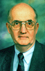

The field of quantitative remote sensing as we now know it was greatly influenced by Dave. As practitioners and analysts, we are all very much in his debt for the legacy he left, not only through his technical accomplishments but also by his leadership.
Among his many ground-breaking contributions he helped establish the designs of the first three Landsat satellites in 1967-68 through his chairmanship of the Sensors and Data Systems Panel of the National Research Council’s Study on Peaceful Uses of Earth Oriented Satellites; and in 1975 he chaired the NASA Thematic Mapper Working Group which defined the spectral bands and system parameters for the TM flown on Landsat 4 and 5.
Importantly, he was one of the originators of the concept of multispectral sensing for deriving information about the Earth’s land resources from aircraft and spacecraft. From as early as 1966 he pioneered the use of pattern recognition techniques for identifying and mapping land cover types from multispectral image data. In an era where we are now consumed with the use of deep learning applied to multispectral and hyperspectral image data, it is fitting to give pause and recognize that it all started with Dave’s experience in signal processing being brought to bear on image analysis using maximum likelihood estimation. Although that was 50 years ago now, it laid the very basis for the field of quantitative remote sensing. Similarly, Dave was a champion of hyperspectral imaging and pioneered development of algorithms to address the associated opportunities and challenges in its analysis.
Dave was a graduate of Purdue University in Indiana where he earned his BSEE (1956), MSEE (1958) and PhD (1962) degrees, and then spent his career as a teacher and researcher in the School of Electrical and Computer Engineering (ECE). He served periods as Acting Head and Coordinator of Graduate programs of the School of ECE, and as Associate Dean of Engineering
As with his scholarly work more generally, Dave’s career at Purdue was distinguished. He served as Director of Purdue’s internationally recognized Laboratory for Applications of Remote Sensing (LARS) from 1969 to 1981. During his tenure, the staff of the Laboratory grew tenfold as did its funding. Much of the groundwork for the applications of remote sensing in agriculture, forestry and soil science was established under him as Director of LARS, as was the evolution of many of the procedures for image processing and analysis that we take for granted today.
Dave was the recipient of many prestigious awards. He was given the NASA Exceptional Scientific Achievement Medal in 1973 for his work in the field of machine analysis methods for remotely sensed earth observational data. In 1967 he received the NASA and the U.S. Department of Interior’s William T. Pecora Award on behalf of the LARS. He was also the 1990 recipient of the William T. Pecora Award in recognition of his individual contributions. In 1992 he received the IEEE Geoscience and Remote Sensing Society’s Distinguished Achievement Award, and its Education Award in 2003. In 2005 he was elected to the National Academy of Engineering, the highest recognition an engineer can receive in the United States. Dave was a Life Fellow of the IEEE.
As much as he was proud of these awards, he was even more proud of his recognition as a teacher and of his influence on many generations of undergraduate and graduate students. He was granted many best teacher awards from ECE and from Purdue Engineering as a whole. Many of his graduate students have gone on to their own distinguished careers.
Dave was President of the IEEE Geoscience and Remote Sensing Society in 1986-87 and was a member of the Administrative Committee (AdCom) from 1979 to 1990. When he retired, he was recognized by the Society with an Honorary Workshop entitled IEEE Workshop on Advances in Techniques for Analysis of Remotely Sensed Data held at the NASA Goddard Space Flight Center in 2003; that led to a special edition of the Transactions in March 2005 to honor his lifetime achievements. In 2013 the Society instituted the GRSS David Landgrebe Award as a GRSS career award presented for outstanding contributions in the field of remote sensing image analysis.
David Landgrebe was a mentor, advisor, friend and colleague. We are all the richer for having known him, and having benefitted from his wisdom, insight, collaboration and warmth over many years. We have all lost something with his passing, because it signals the end of an era. His legacy, however, will live on in the knowledge that much of our particular niche in the field of science and engineering has been built on the shoulders of a real visionary.


