Mathematical Morphology in Geoscience, Remote Sensing and Geospatial Data Science: An Overview
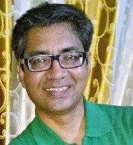
Webinar Speaker: B. S. Daya Sagar
- Tuesday, March 2, 2021
- 4:00 PM CET (Central European Time)
- 10:00 AM US Eastern time
- Sponsored by GRSS
About the Webinar
Data available at multiple spatial/spectral/temporal scales pose numerous challenges to the data scientists. Of late researchers paid wide attention to handling such data acquired through various sensing mechanisms to address intertwined topics—like pattern retrieval, pattern analysis, quantitative reasoning, and simulation and modeling—for better understanding spatiotemporal behaviors of several terrestrial phenomena and processes.1
Georges Matheron and Jean Serra of the Centre of Mathematical Morphology, Fontainebleau founded Mathematical Morphology (MM).2-5 Since the birth of MM in the mid-1960s, its applications in a wide-ranging disciplines have illustrated that intuitive researchers can find varied application-domains to extend the applications of MM. Mathematical Morphology is one of the better choices to deal with the aforementioned intertwined topics. Various original algorithms and techniques that are mainly based on mathematical morphology have been developed and demonstrated.
This lecture that presents an overview of mathematical morphology and its applications in geosciences, remotely sensed satellite data and Digital Elevation Model (DEM) processing and analysis, as well as geospatial data sciences, would be useful for those with research interests in image processing and analysis, remote sensing and geosciences, geographical information sciences, spatial statistics, and mathematical morphology, mapping of earth-like planetary surfaces, etc. The content of this broad overview of the lecture will be offered in two parts. In the first part, basic morphological transformations would be covered. An overview of the applications of those transformations, covered in the first part, to understand the granulometries, morphological filtering, morphological interpolations and extrapolations would be given with several case studies during the second part.
Bibliography
- B. S. Daya Sagar and Jean Serra, 2010, Preface: Spatial Information Retrieval, Analysis, Reasoning and Modelling, International Journal of Remote Sensing, v. 31, no. 22, p. 5747-5750.
- Georges Matheron, 1975, Random Sets and Integral Geometry (New York: John Wiley & Sons).
- Jean Serra, 1982, Image Analysis and Mathematical Morphology, Academic Press: London, p. 610.
- Pierre Soille, 2010, Morphological Image Analysis: Principles and Applications, Springer, p. 408.
- B. S. Daya Sagar, 2013, Mathematical Morphology in Geomorphology and GISci, CRC Press: Boca Raton, p. 546.
Speaker’s Bio
B. S. Daya Sagar is a Full Professor of the Systems Science and Informatics Unit (SSIU) at the Indian Statistical Institute. Sagar received his MSc and Ph.D. degrees in Geoengineering and Remote Sensing from the Faculty of Engineering, Andhra University, Visakhapatnam, India, in 1991 and 1994 respectively. He is also the first Head of the SSIU. Sagar has made significant contributions to the field of geosciences, with special emphasis on the development of spatial algorithms meant for geo-pattern retrieval, analysis, reasoning, modeling, and visualization by using concepts of mathematical morphology and fractal geometry. He has published over 85 papers in journals and has authored and/or guest-edited 11 books and/or special theme issues for journals. Learn more about Prof. Dr. B. S. Daya Sagar.


