The 2023 IEEE GRSS Data Fusion Contest, organized by the Image Analysis and Data Fusion Technical Committee (IADF TC) of the IEEE Geoscience and Remote Sensing Society (GRSS), the Aerospace Information Research Institute under the Chinese Academy of Sciences, the Universität der Bundeswehr München, and GEOVIS Earth Technology Co., Ltd. aims to push current research on building extraction, classification, and 3D reconstruction towards urban reconstruction with fine-grained semantic information of roof types.
To this aim, the DFC23 establishes a large-scale, fine-grained, and multi-modal benchmark for the classification of building roof types. It consists of two challenging competition tracks investigating the fusion of optical and SAR data, while focusing on roof type classification and building height estimation, respectively. The data provided by the DFC23 includes several novel properties:
Globally Distributed Large-Scale Dataset. A novel large-scale urban building classification and reconstruction dataset is provided. Buildings are distributed across seventeen cities in six continents to cover a wide range of different building styles. This allows capturing the heterogeneity of cities in different continents with various landforms.
Fine-Grained Roof Type Categories. The buildings are labeled according to a detailed (fine-grained) categorization of roof types. The DFC23 provides nearly 300k instances with twelve different types of building roofs which renders building classification significantly more challenging.
Multimodal Data. To facilitate multimodal data fusion, not only optical imagery, but also Synthetic Aperture Radar (SAR) images are provided. The information captured by these different modalities can be jointly exploited, potentially resulting in the development of more accurate building extraction and classification models.
Track 1: Building Detection and Roof Type Classification
This track focuses on the detection and classification of building roof types from high-resolution optical satellite imagery and SAR images. The SAR and optical modalities are expected to provide complementary information. The given dataset covers seventeen cities worldwide across six continents. The classification task consists of twelve fine-grained, predefined roof types. Figure 1 shows an example.
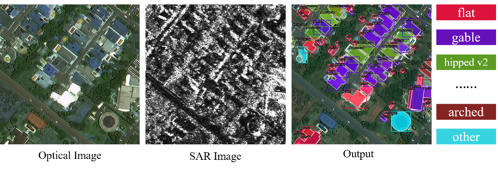 Figure 1: An example image tile of the provided multi-modal data (optical and SAR) for building detection and roof type classification.
Track 2: Multi-Task Learning of Joint Building Extraction and Height Estimation
This track defines the joint task of building extraction and height estimation. Both are two very fundamental and essential tasks for building reconstruction. Same as in Track 1, the input data are multimodal optical and SAR satellite imagery. Building extraction and height estimation from single-view satellite imagery depend on semantic features extracted from the imagery. Multi-task learning provides a potentially superior solution by reusing features and forming implicit constraints between multiple tasks in comparison to conventional separate implementations. Satellite images are provided with reference data, i.e., building annotations and normalized Digital Surface Models (nDSMs). The participants are required to reconstruct building heights and extract building footprints. Figure 2 shows an example.
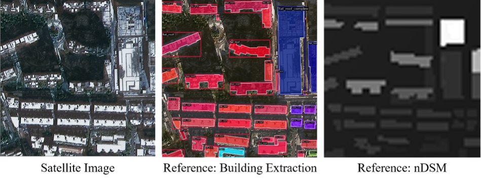 Figure 2: An example for joint building extraction and height estimation.
Competition Phases
The contest in both tracks will consist of two phases:
Phase 1: Participants are provided with training data and additional validation images (without corresponding reference data) to train and validate their algorithms. Participants can submit results for the validation set to the Codalab competition website (Track 1, Track 2) to get feedback on the performance. The performance of the best submission from each account will be displayed on the leaderboard. In parallel, participants submit a short description of the approach used to be eligible to enter Phase 2.
Phase 2: Participants receive the test data set (without the corresponding reference data) and submit their results within seven days from the release of the test data set. After evaluation of the results, four winners for each track are announced. Following this, they will have one month to write their manuscript that will be included in the IGARSS 2023 proceedings. Manuscripts are 4-page IEEE-style formatted. Each manuscript describes the addressed problem, the proposed method, and the experimental results.
Calendar
- January 3: Contest opening: release of training and validation data
- January 4: Evaluation server begins accepting submissions for validation data set
- February 28: Short description of the approach in 1-2 pages for each track is sent to iadf_chairs@grss-ieee.org (using the IGARSS paper template)
- March 7: Release of test data; evaluation server begins accepting test submissions
- March 13: Evaluation server stops accepting submissions
- March 15: Updated and final description of the approach
- March 28: Winner announcement
- April 23: Internal deadline for papers, DFC Committee review process
- May 22: Submission deadline of final papers to be published in the IGARSS 2023 proceedings
The Data
Data Source
Images of the DFC23 dataset are collected from the SuperView-1 (or “GaoJing” in Chinese), Gaofen-2 and Gaofen-3 satellites, with spatial resolutions of 0.5 m, 0.8 m, and 1m, respectively. Normalized Digital Surface Models (nDSMs) provided for reference in Track 2 are produced from stereo images captured by Gaofen-7 and WorldView with a ground sampling distance (GSD) of roughly 2 m. Data was collected from seventeen cities on six continents to provide a large and representative data set of high diversity regarding landforms, architecture, and building types.
Category design
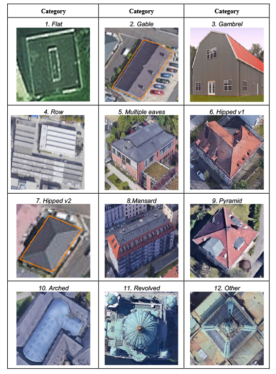
There are twelve fine-grained roof type classes based on the geometry of the roof. Table 1 provides the detailed definition of these roof types.
Table 1 Categories of roof type
Dataset partition
The data is partitioned into three partitions, which are training set, validation set and test set. The participants can access the training set (including the optical images, the corresponding SAR images, and the reference) and the validation set (without reference) in the development phase. In the test phase, the test set (without reference) will be released.
Submission and Evaluation
Track 1: Participants should submit results to the Codalab competition website to get feedback on the performance. The submitted format should follow the MS COCO format (in a JSON file), including segmentation results represented by polygons (i.e., a sequence of points to delineate the building contours) or RLE (run-length encoding), one fine-grained category with a confidence for each instance and one optional bounding box.
For evaluation, we adopt the standard COCO metric ![]() (the IoU threshold is 0.5), where the loU is evaluated based on the masks converted from the ground truth masks and the submitted masks. The participants with the highest
(the IoU threshold is 0.5), where the loU is evaluated based on the masks converted from the ground truth masks and the submitted masks. The participants with the highest ![]() are declared as the winners. It is noted that
are declared as the winners. It is noted that ![]() is a very strict metric. Categories are taken into consideration when computing the IoU score.
is a very strict metric. Categories are taken into consideration when computing the IoU score.
Track 2: Participants should submit results to the Codalab competition website to get feedback on the performance. The submitted results should include two parts. The first part is a building extraction result, which is the same as the previous track with the only exception that the category is not taken into consideration in this track. The second part is a pixel-wise height estimation result, which is a map of the same resolution as the input. The second part should be a (possibly compressed) tif file with the same name as the corresponding optical image.
For evaluation, the metric of the building extraction is the same as Track 1 (categories are not taken into consideration) and the metric of height estimation is threshold accuracy ![]() , where
, where ![]() is the total number of pixels and
is the total number of pixels and ![]() is the number of pixels that meet
is the number of pixels that meet ![]() , where
, where ![]() is the reference height and
is the reference height and ![]() is the predicted height. The final metric is the average of the two metrics, i.e.,
is the predicted height. The final metric is the average of the two metrics, i.e., ![]() .
.
Baseline
A baseline that shows how to use the DFC23 data to train models, make submissions, etc., can be found here.
Results, Awards, and Prizes
The first, second, and third and fourth-ranked teams in each track will be declared as winners.
Present their approach in an invited session dedicated to the DFC23 at IGARSS 2023
- Publish their manuscripts in the proceedings of IGARSS 2023
- Be awarded IEEE Certificates of Recognition
- The first to third-ranked teams of each track will receive $5,000, $2,000, and $1,000 (USD), respectively, as a cash prize.
- The authors of the first and second-ranked teams of each track will co-author a journal paper which will summarize the outcome of the DFC23 and will be submitted with open access to IEEE JSTARS.
- Top-ranked teams will be awarded during IGARSS 2023, Pasadena, USA in July 2023. The costs for open-access publication in JSTARS will be supported by the GRSS. The winner team prize is kindly sponsored by the organizing partners.
The Rules of the Game
- The dataset can be openly downloaded at ieee-dataport.org/
competitions/2023-ieee-grss- data-fusion-contest-large- scale-fine-grained-building- classification. - Validation and test data can be requested by registering for the Contest at IEEE DataPort.
- To enter the contest, participants must read and accept the Contest Terms and Conditions.
- Participants of the contest are intended to submit results as the Submission and Evaluation Section
- The results will be submitted to the Codalab competition website (Track 1, Track 2) for evaluation.
- Ranking between the participants will be based on the metrics as described in the Submission and Evaluation Section.
- The maximum number of trials of one team is five per day in the test phase.
- The submission server of the test phase will be opened on March 7, 2023 at 23:59 UTC-12 hours. The deadline for result submission and final description is March 15, 2023, 23:59 UTC-12 hours (e.g., March 16, 2023, 6:59 in New York City, 12:59 in Paris, or 19:59 in Beijing).
- Each team needs to submit a short paper of 1–2 pages clarifying the used approach, the team members, their Codalab accounts, and one Codalab account to be used for the test phase by Feburary 28, 2023. Please send a paper to iadf_chairs@grss-ieee.org using the IGARSS paper template. Only teams that have submitted the short description complete with all information will be admitted to the test phase.
- For the winning teams, the internal deadline for full paper submission is April 23, 2023, 23:59 UTC – 12 hours (e.g., April 23, 2023, 7:59 in New York City, 13:59 in Paris, or 19:59 in Beijing).
- Important: Only team members explicitly stated on these documents will be considered for the next steps of the DFC, i.e., being eligible to be awarded as winners and joining the author list of the respective potential publications (IGARSS23 and JSTARS articles). Furthermore, no overlap among teams is allowed, i.e., one person can only be a member of one team. Adding more team members after the end of the development phase, i.e., after submitting these documents is not possible.
- Persons directly involved in the organization of the contest, i.e., the (co-)chairs of IADF as well as the co-organizers are not allowed to enter the contest. Please note that IADF WG leads can enter the contest. They have been actively excluded from all information concerning the content of the DFC to ensure a fair competition.
Failure to follow any of these rules will automatically make the submission invalid, resulting in the manuscript not being evaluated and disqualification from the prize award.
Participants to the Contest are requested not to submit an extended abstract describing their approach to tackle the DFC23 to IGARSS 2023 by the corresponding conference deadline in January 2023. Only contest winners (participants corresponding to the best-ranking submissions) will submit a 4-page paper describing their approach to the Contest by April 23, 2023. The received manuscripts will be reviewed by the Award Committee of the Contest, and reviews will be sent to the winners. Winners will submit the 4-pages full-paper to the Award Committee of the Contest by May 22, who will then take care of the submission to the IGARSS Data Fusion Contest Community Contributed Session by May 31, 2023, for inclusion in the IGARSS Technical Program and Proceedings.
Terms and Conditions
Participants of this challenge acknowledge that they have read and agree to the following Contest Terms and Conditions:
- In any scientific publication using the data, the data shall be referenced as follows: “[REF. NO.] 2023 IEEE GRSS Data Fusion Contest. Online: grss-ieee.org/technical-committees/image-analysis-and-data-fusion/”.
- Any scientific publication using the data shall include a section “Acknowledgement”. This section shall include the following sentence: “The authors would like to thank the IEEE GRSS Image Analysis and Data Fusion Technical Committee, Aerospace Information Research Institute, Chinese Academy of Sciences, Universität der Bundeswehr München, and GEOVIS Earth Technology Co., Ltd. for organizing the Data Fusion Contest”.
- Any scientific publication using the data shall refer to the following paper:
- [Huang et al., 2022] Huang, X., Ren, L., Liu, C., Wang, Y., Yu, H., Schmitt, M., Hänsch, R., Sun, X., Huang, H., Mayer, H., 2022. Urban Building Classification (UBC) – A Dataset for Individual Building Detection and Classification from Satellite Imagery. In: Proceedings of the IEEE/CVF Conference on Computer Vision and Pattern Recognition. pp. 1413-1421.
Acknowledgments
The IADF TC chairs would like to thank the Aerospace Information Research Institute under the Chinese Academy of Sciences, the Universität der Bundeswehr München, and GEOVIS Earth Technology Co., Ltd. for providing the data and the IEEE GRSS for continuously supporting the annual Data Fusion Contest through funding and resources.
The winners of the competition will receive a total of $16k as prizes, courtesy of GEOVIS Earth Technology Co., Ltd.