


From April 1st to May 14th, IADF organized a photo contest with the theme “Eye in the Sky”. Participants could submit enlightening illustrations that explain their method, fancy visualizations of the input, intermediate representations, or final results, or a visual summary of a core problem that they are aiming to solve. Evaluation was based on social media engagement and votes from an expert panel based on uniqueness, clarity of expression of the write-up, creativity, and innovativeness.
Now, we are thrilled to share the winners of the GRSS IADF Photo Contest 2023! We received so many amazing entries that it was hard to choose just one. That’s why we decided to select three winners who impressed us the most with their creativity, innovativeness, and originality.
Indranil Misra, Space Applications Centre (SAC), Indian Space Research Organisation (ISRO), India.
www.linkedin.com/feed/update/urn:li:activity:7055491289445728257/
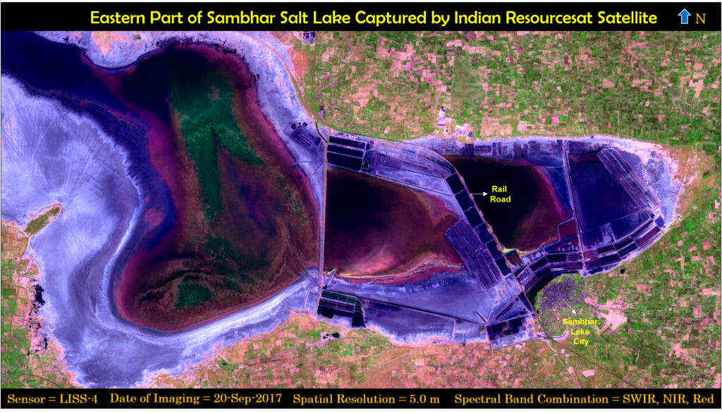
Indian Resourcesat satellites provide vital multispectral information in Visible and SWIR wavelength range of electromagnetic spectrum for resource monitoring. LISS-4 is one of the payload onboard Resourcesat that capture remote sensing images at a spatial resolution of 5.0 meters and have three spectral bands in visible wavelength region. The LISS-4 processed image shown captured eastern part of Sambhar Salt Lake. Sambhar Lake is India’s largest inland salt lake that is located 80 km south-west of Jaipur, India and also designated as Ramsar site (wetland of international importance). LISS-4 spectral bands are separated in the focal plane at different angles that results into Band-to-Band mis-registration. The bands are co-registered over each using multi-stage feature detection techniques to achieve sub-pixel level accuracy. LISS-4 sensor does not have SWIR band that have lot of potential for earth observation applications spans from wetland delineation, forest fire monitoring to snow & cloud discrimination. We have synthesized SWIR band on ground at a spatial resolution of 5.0 meters using novel deep learning model. Adversarial learning framework guided by Spatio-Spectral Laplacian attention mechanism regulate the process of SWIR band Synthesis that uses Low Resolution (LR) and existing High Resolution (HR) concurrent spectral bands. In addition, we have enhanced LISS-4 color composite image using Contrast Limited Adaptive Histogram Equalization (CLAHE) for better feature demarking and generate best representative LISS-4 image for visualization and analysis. The spectacular LISS-4 color image shown is the composite generated using synthesized SWIR, NIR and Red wavelength channels. Sambhar Lake City is clearly visible in the LISS-4 enhanced color image. Rail road is also recognized in the LISS-4 multispectral image that was constructed by the British before India’s independence to provide access from Sambhar Lake city to salt works. LISS-4 processed imagery is a treasure hub for remote sensing applications that showcases the capability of Indian earth observation sensors to map our planet earth for global scientific community.
(c) DLR-HR, JF 01/04/2023
Jens Fischer, Joel Amao-Oliva, Muriel Pinheiro, Marc Jaeger, Rolf Scheiber, Martin Keller, Ralf Horn, and Andreas Reigber from the Microwaves and Radar Institute, German Aerospace Center (DLR).
www.linkedin.com/in/jens-fischer-43b4145a/recent-activity/all/
www.youtube.com/channel/UCc3j0KEO4I2jAowiT1esc1A
www.dlr.de/hr/en
www.dlr.de/hr/gallery
www.dlr.de/hr/360
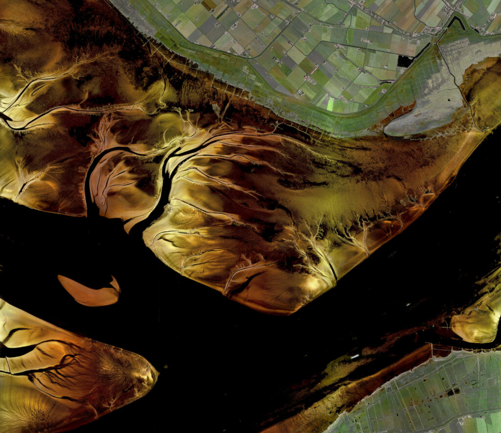
Acquisition. This image is a mosaic of high-resolution radar images taken with DLR’s airborne Synthetic Aperture Radar (SAR) system “F-SAR” over the mouth of the river Elbe near Hamburg, Germany. The extent of the entire scene is about 10 km x 10 km at a resolution of 50 cm x 50 cm per pixel and the total acquisition time was about 2 hours.
What is special in this image? Synthetic Aperture Radar (SAR) imaging techniques are combined for the first time with High Dynamic Range (HDR) techniques known from optics. Normally, the tidal flats are imaged with dark colors so that they remain largely hidden. A global increase in contrast and brightness would drive the pixels on land into saturation (white color). We therefore decouple land and tidal flats so that both parts of the image can be optimized independently.
Colors. The image was taken at a wavelength of about 9 cm (S-band), a wavelength at which humans cannot see. We therefore get glossy effects on structures (sandbanks and meadows) that would not be glossy with human vision. The colors of the image correspond to polarimetric properties of electromagnetic waves and they are chosen so that roofs of houses appear red, vegetation green and sand in golden colors.
Vaibhav Tyagi, SIGMA Research Lab, Department of Astronomy, Astrophysics and Space Engineering, Indian Institute of Technology Indore, India.
Personal Linkedin: Vaibhav Tyagi
IEEE Student Branch IIT Indore Linkedin: IEEE Student Branch IIT Indore
SIGMA Research Lab Linkedin: SIGMA Research Lab, IIT Indore
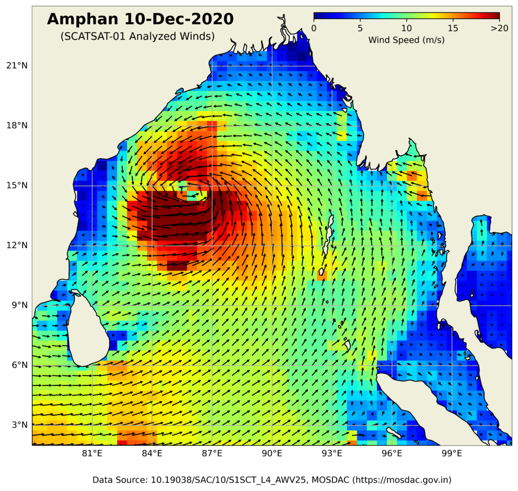
This image is an analysis of the Amphan cyclone that occurred on December 10, 2020, using satellite observations from the SCATSAT-01 scatterometer. The image shows the visual representation and wind circulation of the cyclone. This image is particularly interesting because it showcases the power and destruction of nature. The Amphan cyclone was one of the most intense tropical cyclones to hit the Bay of Bengal in recent years. It caused widespread damage to homes, crops, and infrastructure, leaving thousands of people homeless and in need of assistance. It highlights the need for early warning systems, evacuation plans, and infrastructure that can withstand the force of powerful storms. In this way, this image can serve as a valuable educational tool for communities and decision-makers around the world. Furthermore, the image’s scientific significance cannot be understated. By analysing the wind circulation patterns captured in the image, one can gain a better understanding of the dynamics of tropical cyclones and use this information to develop more accurate forecasting models.This image conveys a powerful message about the importance of disaster preparedness and response and its scientific significance in advancing our understanding of tropical cyclones.
Contact: For any query, contact iadf_chairs@grss-ieee.org with the subject line “Photo Contest”.


