


The IEEE Geoscience and Remote Sensing Society Young Professionals are proud to announce the winners of our 2022 Earth at Risk Image contest.
Our contest had around 35 amazing entries from over 20 countries. We were astounded by the variety, quality, and impact of the submitted Earth Observation data images highlighting different environmental issues in this first version of the contest.
This year’s contest was judged by the REACT Technical Committee team:
Prof. Irena Hanjsek from ETH Zürich and German Aerospace Center, Dr. Carlos Lopez Martinez from Universitat Politècnica de Catalunya, and Prof. Avik Bhattacharya for the Indian Institute of Technology Bombay.
We want to thank all of the entrants to this year’s contest! It has been an honor to witness each of your work.
We are pleased to share the top three images selected by our judges and the people’s choice from the public vote.
Check below to see the images that amazed everyone the most.
First Place
Precious Eguagie-Suyi, Federal University of Akure, Nigeria
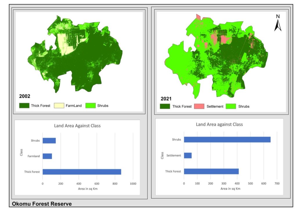
Okomu Forest Reserve © Precious Eguagie-Suyi/Earth at Risk Image Contest 202
“Okomu Forest Reserve is a Place designated by the British colonial government in 1912 to persevere some endangered species of animals in the southwestern side of Benin City, Edo State, Nigeria. It has a land mass of about 1081 Km2. Okomu Forest Reserve has a National Park where tourists would be opportune to see some of these animals. But over the years there has been a drastic reduction in the extent of this forest reserve. The image shows the Land Use Land Cover of the forest reserve as of 2002 with a forest extent of about 78% but as of 2021, the forest has reduced to about 37% of the landmass. It also shows the encroachment of settlement in this forest reserve. All these have led to the great loss of this endangered species and more exposure of the environment to climate change due to deforestation. The Earth Observation data used for this image is Landsat 7 and Landsat 8, it is a multispectral satellite having a Spectral resolution of 30m and its temporal Resolution of 16 days. 2002 was used because of the unavailability of satellite imagery in the early times over these and also the cloud effect. If implemented remote sensing and GIS can be used to keep track of this Forest reserve to prevent further deforestation, and settlement encroachment to prevent the final loss of this forest reserve. “ Precious Eguagie-Suyi
Second Place
Lorenzo Ammirati, University of Naples Federico II, Italy
![]()
Córrego do Feijão Mine © Lorenzo Ammirati/Earth at Risk Image Contest 2022
„Brumadinho, Córrego do Feijão mine (Minas Gerais, Brazil) on 25 January 2019 the iron ore tailing “Dam B1” was affected by a catastrophic failure causing a huge flood that destroyed the mining officers, houses, roads and 257 people died and seriously affecting the local flora and fauna as a result of the collapse. The environmental impact after the Brumadinho dam disaster has also caused several issues to the surrounding lands. The map allows to assess the land cover affected by the flood due to dam failure by using SENTINEL-2 multispectral data. The RGB composite multispectral mapping approach represents a preliminary environmental helpful analysis for mapping flooded areas.“ Lorenzo Ammirati
Third Place
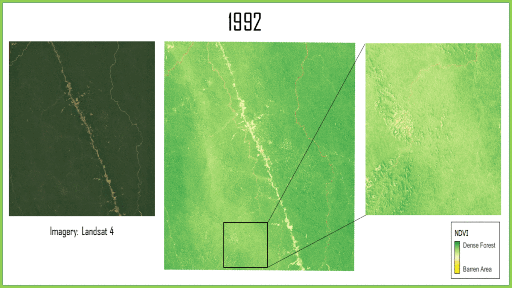
Forest Fragmentation © Sweata Katwala/Earth at Risk Image Contest 2022
„Forest fragmentation is a phenomenon in which large parts of continuous forests are broken down and chopped off to form patches that are either used as road networks, agricultural land, or any other anthropological developments. The image submitted is of the Southwestern part of the State of Para, Brazil. Landsat 4, 5, and 9 images from 1992 till 2022 were taken to depict how the forest has been cut off and the area has been converted to indigenous land. According to Brazil’s official deforestation data, Pará lost 7.2 million hectares of forest cover between 2000 and 2019, and about 6 percent of its mature forest. In 2020, deforestation rose to a 12-year high, hampering environmental enforcement. This in turn results in higher temperatures, extreme weather, and rising sea levels. Hence, it clearly proves “Earth at Risk”.“ Sweata Katwala
People’s Choice
Indranil Misra, Space Applications Centre, Indian Space Research Organisation (ISRO), India
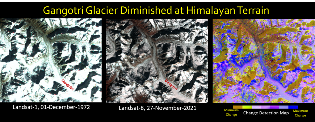
The Gangotri Glacier © Indranil Misra /Earth at Risk Image Contest 2022
„Multi-decadal earth observation images are a treasure hub that helps to monitor gradual changes in glaciers around the globe. Gangotri glacier is one of the biggest glacier at Himalayan terrain. This glacier is the one of the major source of Ganges, which is a trans-boundary river flow through India and Bangladesh. The multi-temporal earth observation data products from Landsat series helps to monitor the diminished Gangotri glacier. Landsat-1 Multi-Spectral Scanner (MSS) remote sensing image of year 1972 available over Gangotri region that showcase historical feature characteristics. Landsat-8 Operational Lander Imager (OLI) is the next generation remote sensing satellite by USGS-NASA capable to image Earth at better spatial, spectral, radiometric and temporal resolutions. The Gangotri glacier recently captured by Landsat-8 OLI satellite and fortunately in the same seasonal time interval. The bi- temporal orthorectified Landsat image pair provides an opportunity to detect changes over Gangotri glacier region. Developed multi-variate statistical technique to generate change detection map over Gangotri glacier. The blue color identifies the maximum change pockets over Gangotri glacier. It is clearly found that both length and breadth of Gangotri glacier is reduced in past 50 years. This is a major concern for living beings around Indian sub-continent where these big glaciers are major source of fresh drinking water and plays a critical role to maintain the biodiversity. The remote sensing data products provides pivotal information about different glaciers that can save our planet Earth from major risk and continuously make it habitable for our future generations.“ Indranil Misra
Congratulations to the Earth at Risk Image Contest Winners for 2022!


