Past Distinguished Lecturers
The Distinguished Lecturer Program (DLP) is a service of the GRSS and its members to support our chapter activities. Our goal is to provide chapters with access to leading professionals in geoscience and remote sensing and discuss novel topics in current research. This is an opportunity for the GRSS membership to hear interesting talks about work being done in our fields of interest and to meet some of the prominent members of our Society.
Past Speakers


Alejandro Frery
Instituto de Computação, Universidade Federal de Alagoas, Maceió Brazil
Statistics and Information Theory in Remote Sensing with SAR


Christopher J. Ruf
The University of Michigan, Ann Arbor, USA
NASA Cyclone Global Navigation Satellite System (CYGNSS) Earth Venture Mission


David Long
Brigham Young University, Provo, UT, USA
Satellite Scatterometry: Winds, Vegetation, and Ice


Gustau Camps-Valls
Universitat de València, Spain
Machine Learning for Remote Sensing Data Analysis


Jun Li
Sun Yat-Sen University, China
Recent Advances in Spectral–Spatial Hyperspectral Image Classification


Lori Mann Bruce
Tennessee Technological University, USA
Hyperspectral Image Analysis with Applications of UAVs for Precision Agriculture


Mahta Moghaddam
University of Southern California, USA
Microwave Sensing Through the Subsurface for Addressing the Water Puzzle


Peter Baumann
Jacobs University, Germany
(1) Datacubes as a Novel Paradigm for Massive Earth Data Analysis: Concepts and Implementation; (2) Big Data Standards in OGC, ISO, and INSPIRE: Overview, Concepts, and Use
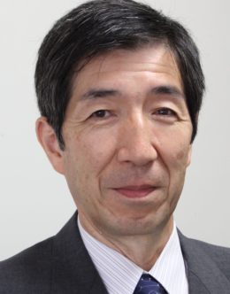

Toshio Iguchi
NASA Goddard Space Flight Center, USA
Radar Measurement of Precipitation from Space


Lisa Haskell
UK
Data Harmonisation and Interoperability in the Space Industry


Ilke Demir
USA
Deep learning, Computer vision, Automatic extraction, Generative models, Urban reconstruction


Rohit Singh
India
GIS, Artificial Intelligence, fast.ai, PyTorch, TensorFlow, CycleGAN


Tao Guo
China
Development of application solutions hub in Earth Observation industry


